Tuesday, April 28, 2009

Pound for pound.....

On a recent ride home I noticed a hawk a few hundred feet in the sky with a couple of ravens much lower below. The ravens were occasionally swooping toward the ground following something. That something ran across the road in front of me and stopped just past the fence line as I slowed to a stop next to him. While I didn't get a picture of him myself, the above photo has identical coloration to the one I saw. The badger turned around and looked at me stopped in the road, then continued on his way to pretty much anywhere he wanted to go.
Posted by Picasa

Monday, April 27, 2009

Industrial MapQuest

The above colorfully illustrated diagram shows a representation of a mining shovel and the geology surrounding it from an overhead view.  The gray is the grade that vehicles travel on and the pink and brown are types of ore.  The shovel has a high precison GPS (compliments of our Defense Department) and the mine drill rigs have taken samples of the ore along with its GPS location.  Combining the location of the shovel and the location of samples, the dispatch program lets the shovel know where to dig and also tells the haul truck drivers where to take the rocks--waste dump, dedicated leach pads, reuse leach pads, mill or gravity plant.  I'll include descriptions of each of these in the future but for know, technology is driving the efficiencies unheard of in mining---whether it is gold, copper or coal.
Posted by Picasa

Saturday, April 25, 2009

Rockslide!!!!

This picture shows a rockslide in the pit. Each of the squared off steps (benches) are 35 feet high and work their way through a variety of rocks as the pit gets bigger. A few of the rock formations are not stable due to strength, fractures or faults. Rockslides in these areas are known weeks if not months in advance through the use of hundreds of prisms placed in key locations by the geologists. They report each morning on the condition of the major features in the pit along with any of the prisms that have moved. The movement is usually well under 3/4" which is typical for the heating and cooling between day and night. Once a future slide becomes evident, berms are put in place, roads rerouted, and if time allows, wider benches if needed.
Posted by Picasa

Friday, April 24, 2009

Early Adopter


A fellow blogger turned me on to this new USB drive configuration. Hot swapping SATA drives has never been easier. Here is the Big Kahuna (500 gigs of file storage) slowing easing into retirement. This drive has been giving me fits since the move to Gold Country. And as with all things technology driven, the files from the Big Kahuna are being moved to Godzilla---a 1 terabyte drive :)
Posted by Picasa

Thursday, April 23, 2009

Clouds Rolling In--Literally!!!!


With the elevation around a mile above sea level, and with a narrow valley with mountains up to 11,000 ft on either side, the low pressure fronts literally get pushed up and over the peaks......and then roll down to the altitude they were on the other side minus some snow or rain of course.
Posted by Picasa

Tuesday, April 21, 2009

Parking Lot Congestion

The rocks being poured in this picture have gold in higher concentrations than typical for the mine (still measured in milli-ounces of gold per ton of rock). The ore bearing rock has been mined in the pit, loaded onto haul trucks, dumped into a crusher and then conveyed to a "reusable leach pad". After the conveyor pours the newly created gravel, teams of people follow behind and plumb a network for the cyanide solution to drip onto the mound. Unlike the larger pads, this leach pad is just asphalt that is very similar to a large mall parking lot. The ore usually stays no longer than ~60 days before a high percentage of the gold has been removed and then the gravel is transferred to the larger leach pads for years of leaching what gold is left. The conveyor pictured here is a one of a kind as it creates its own bed to travel on in a slow continuous loop.
Posted by Picasa

Monday, April 20, 2009

A New Beginning

Most of the gold in this area of Nevada is measured in the milli-ounces per ton of ore. In order to separate it from the rock it is disolved in a weak cyanide solution that is drip irrigated onto large hills of the ore. This picture shows the beginnings of a new leach pad with the drain lines and vinyl liner being put in place to drain off the "pregnant" solution after it percolates through the ore. Typical hill sizes are better measured with an odometer and weigh into the hundreds of millions of tons of gold bearing rock.
Posted by Picasa

Sunday, April 19, 2009

I'm eating good


There are somes folks that wonder what's for breakfast way out here in gold country....About the same as any other place I've lived in the past 47 years.....except no cast iron skillet anymore.
Posted by Picasa

Friday, April 17, 2009

Plug and Pray

While most of the heavy metal here in Nevada runs on diesel (to the tune of almost 1,000,000 gallons a month) the big shovels in the open pit use electricity to move and dig. Giant extension cords are draped around the pit to provide the needed power. 
Here is a stand near one of the shovels with the male and female adapters locked together. The table is about 2 feet by 4 feet. The voltage used is 7200 Vac and there is a special pin located in the plug which signals the transformer feeding the shovel to shunt the power making it safe(?) to handle.
Posted by Picasa

Thursday, April 16, 2009

Winged Brothers


On my trip to Nevada I spent over 1700 miles on Interstate 40.  It was a great ride across America and only this way of traveling shows the diverse nature of our country. While traveling through Oklahoma City I noticed what appeared to be an Air Force base literally along the south side of the highway. A static display of aircraft showed the rich history of Tinker Air Force base throughout the years. My friends at Google allow me to share what I saw while driving by....I include this link for those of you interested in what they do there.

Tuesday, April 14, 2009

Under Pressure


When shopping to fill my pantry for the first time I bypassed several products because of that bloating you see when food begins to go bad. I made it about halfway through the store when I ran into this tub of Crisco. It was bloated like you see in the picture---along with every other tub. Then I realized that the altitude here in Smokey Valley (~5,000 feet) is causing some products packed in less sturdy packaging (foils, plastics, etc) that are air-tight and packed near sea level to expand quite a bit once shipped to the local general store.
Posted by Picasa

Monday, April 13, 2009

Simple Fix


Near Fallon, Nevada I noticed some of the larger aerial cabling had weights hanging between supports. With some of the near constant wind I've experienced so far I imagine that this keeps the swing of the cable assembly minimized to reduce wear on the embedded steel support cable and helps the clamps keep the proper droop between supports. Obviously this solution uses the little known super power, "Common Sense"!
Posted by Picasa

Sunday, April 12, 2009

Darwin Would Be Proud


Walking in and out of my new home away from home I noticed a familiar face in the still dormant lawn. Dandelions!!! Out here in the high plains they thrive next to the grass they more than likely came with either by seed or sod.
Posted by Picasa

Saturday, April 11, 2009

High Expectations
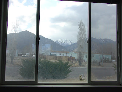
Getting moved in the past day or so.  The picture window (and yes, I do know it needs cleaning mom) looks out onto the summit of what I believe is Mahogany mountain.  It is approximately 7 miles or so distant as a bird flies.  Hiker guides call it an easy jaunt up to the 11,000 mountain peak following Jett Canyon which begins here in Smokey Valley a few miles northwest of the community.  Now where did I put my hiking boots......

Friday, April 10, 2009

Makes it all worthwhile....

We all have doubts from time to time but it's little things like these that keeps it all in focus.
Posted by Picasa

Copse of Wind Catchers

Saw some wind turbines while traveling through the panhandle of Texas. I also noted the reason for their location as my truck had trouble staying in overdrive due to the stiff headwind. If we truly want to change the rules of the game of international politics, we as a nation must use every means available (we have a few spare car plants now) to add renewable sources of energy onto our grids.
Posted by Picasa

Wednesday, April 8, 2009

Slow Ride on the Sunchaser Express

My Mini has been in a bad mood all day. She heard we were driving to Nevada but didn't realize that she'd have to stare at the back end of a Uhaul for 2,000 miles!!! I told her I'd make it up to her when we got to Nevada.....tankful of 93 octane gas should do it :)
Posted by Picasa

Tuesday, April 7, 2009


Along Highway 50 in Nevada, named the "Lonliest highway in America", a very large sand dune appropiately named Sand Mountain lies along the north side of the highway near Fallon. A recent snow shows in the crest of the sand and a raft of campers enjoy the view from on the east side.
Posted by Picasa

Monday, April 6, 2009


No, this sign isn't telling you to watch out for Bugs Bunny's nemesis Toro who "steamed up his tail", but a reminder that you are driving in "open range". From my few trips it appears that the main highways have approximately 150' of easement on either side with fencing running on both sides parallel with the highway. Any roads that join the highway have a "cattle grate" where they intersect the fencing. Smaller, less used roads may have a gate and at times just a loose loop of fencing stretched over a fence post. While all of these work very well I have seen one instance where cattle have gotten through the fence and were grazing peacefully on taller grass inside the easement.
Posted by Picasa

Sunday, April 5, 2009


A sunset photo of a flowering tree in west Tennessee shows that springtime is in the air. An early adapter of the warming weather, its peers surrounding it will soon follow.
Posted by Picasa

Saturday, April 4, 2009

I haven't played the course yet, but its gives me a warm fuzzy feeling about being a member of a world-renowned country club!!
Posted by Picasa

On my trip to Reno yesterday I was driving through the back-end of a recent snow storm. The town of Austin is located fairly high in the mountains and has some of the same small town flavors that most small rural towns do throughout the United States---including the local law enforcement :)
Posted by Picasa

Thursday, April 2, 2009

Topping Off the Load

240 tons of gold ore being topped off with a dash of lime. I was reading a recent blog about water chemistry being too alkaline and here at Round Mountain the opposite is true. The water needs to have a pH around 10.5 for the cyanide to work it's magic on the gold in the rocks so lime is added to each truck load of ore being set out onto the leach pads.
Posted by Picasa

Wednesday, April 1, 2009

Home on the Range

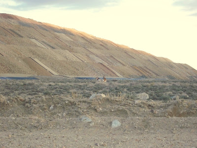
Leaving work this evening I saw an animal run across the road in the distance. Nearing the main highway, I saw that there was not one but two animals and that they were a pair of pronghorn antelope. They did not seem the least bit concerned about me stopping.

The hill in the background is obviously man-made and is called a dedicated leach pad. The black lines running up the sides are plastic pipes that carry water with a very weak cyanide solution (think Rasputin) that is drip irrigated onto the surface of the pad. As the water percolates through the piles of ore, the gold in the rocks bonds with the cyanide. The black roll around the bottom of the hill is the edge of a liner that captures the water so that it can be pumped to the ore processing facility in order to extract the gold using activated carbon and electrolysis.

Posted by Picasa